yahoo Press
Odds of a ‘Super El Nino’ growing, model shows. What that could mean
Images

1 / 12

2 / 12

3 / 12

4 / 12

5 / 12

6 / 12

7 / 12
8 / 12
9 / 12

10 / 12

11 / 12

12 / 12
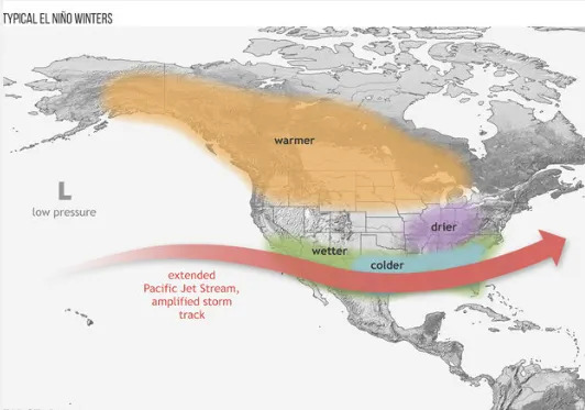
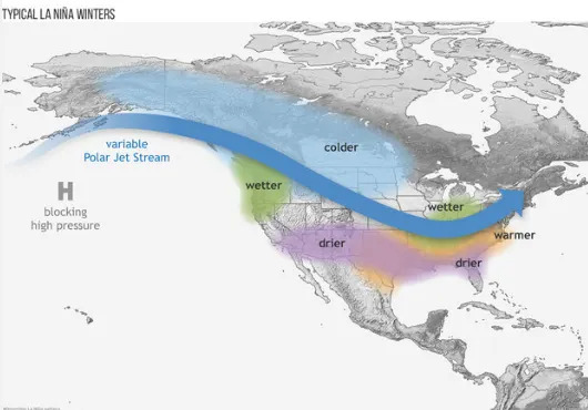
(NEXSTAR) – A renowned research and modeling organization’s most recent forecast shows the planet could see a strong or “Super El Nino” this year.

El Nino is a cyclical and natural warming of patches of the equatorial Pacific that then alters the world’s weather patterns. The phenomenon is dubbed a Super El Nino when the temperature rises at least 2.0°C above normal.

La Nina is marked by cooler than average waters. Both shift precipitation and temperature patterns, but in different ways. El Ninos tend to increase global temperatures and La Ninas depress the long-term rise. La Ninas tend to cause more damage in the United States because of increased hurricane activity and drought, studies have shown.

While we are currently in a La Nina phase, recent models from the European Center for Medium-Range Weather Forecasts (ECMWF) suggest a 98% chance of a moderate El Nino event by August, with an 80% chance of a strong event and a 22% chance of a super event.

“The European (ECMWF) computer model’s signal toward El Niño development later this year lines up with what many of the global climate models have been hinting at recently,” said Nexstar’s chief meteorologist Brian James. “While it’s still early and confidence on exact strength is limited this far out, the overall trend toward a developing El Niño by late summer or fall looks increasingly plausible.”

Gas climbs 43 cents since last week: These states had bigger jumps, data shows

The National Oceanic and Atmospheric Administration (NOAA) released its own outlook Monday, but notes that this time of year the models are notoriously uncertain when it comes to the late summer and beyond. NOAA expects the current La Nina phase to wane within the next several months and enter a neutral phase (a 60% chance from Feb. – April) with the “possibility of a transition to El Nino” after July.

Any effects of a potential El Nino are pattern are still months away, but, if the ECMWF models correctly predict a Super El Nino this fall we may see hotter, drier winters in the northern US and Canada, along with increased rain and flooding across the Gulf Coast and Southeast.

“Of course, the exact regional impacts will depend on how strong the event becomes and how quickly it develops,” James said, “but a transition toward El Niño generally tilts the odds toward a wetter southern U.S. and milder conditions across parts of the northern states heading into winter.”

During La Nina, warm water sticks to a deeper depth, resulting in a cooler surface. And that reduces how much energy goes out into space, said study co-author Yu Kosaka, a climate scientist at the University of Tokyo.

“When there is a transition from La Nina to El Nino, it’s like the lid is popped off,” releasing the heat, explained former NOAA meteorologist Tom Di Liberto, who’s now with Climate Central.

El Nino could bring some relief to those living in parts of the U.S. Southeast as the pattern tends to suppress vertical wind shear, stabilizing the atmosphere and potentially lowering the number of hurricanes.

“As we get closer to the start of hurricane season, confidence is growing that this might be the quietest season since 2015, unless something very unusual happens,” Andy Hazelton, associate scientist at the University of Miami CIMAS, posted on X. “Of course, we could see an impactful storm somewhere (it only takes one), but this setup doesn’t leave much leeway for the Atlantic to have a lot of action.”

The Associated Press contributed to this report.

Copyright 2026 Nexstar Media, Inc. All rights reserved. This material may not be published, broadcast, rewritten, or redistributed.

For the latest news, weather, sports, and streaming video, head to The Hill.