yahoo Press
Will fall be cool, hot or wet? Old Farmer’s Almanac outlook by region
Images
1 / 6

2 / 6

3 / 6

4 / 6

5 / 6

6 / 6
As temperatures continue to climb across much of the country, many people are already wondering what kind of weather fall will bring. Will cooler air arrive early? Will drought-stricken areas see relief? Or will warmth linger into the season?

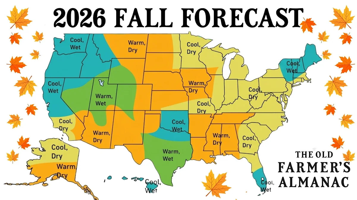
The Old Farmer's Almanac has released its 2026 extended fall forecast, offering a look at what temperatures and precipitation could look like across the United States.

The Almanac, which has been predicting weather since 1818, expects a mixed bag this fall, with some regions forecast to be cooler and wetter than average while others could see warmer and drier conditions.

From the Northeast to the Pacific Coast, here's what the Old Farmer's Almanac predicts for fall 2026.

More: Return of the Dust Bowl? What a strong El Niño may bring to US

"Will our sweaters get more use this fall? It won't feel like fall everywhere," the Old Farmer's Almanac states.

Across the country, the forecast calls for a mix of conditions, with some regions expected to turn wetter while others could remain drier than normal.

According to the forecast, warmer-than-average conditions are expected across parts of the nation's interior from the Northern Plains through the Heartland and into the Deep South during September and October, suggesting drought-stressed areas may not see much relief as the season begins. Meanwhile, much of the eastern United States and Pacific Coast are expected to experience cooler-than-average weather.

Need a raincoat? Check these out on Amazon!

Northeast: Cooler and wetter than average.

Atlantic Corridor: Cooler and drier than average, with less rainfall expected in September and October.

Appalachians: Cooler and drier than normal, with below-average precipitation.

Southeast: Slightly cooler than average, with drier conditions expected across much of the region.

Florida: Cooler and drier in the north; cooler with slightly above-average rainfall in the south.

Lower Lakes: Cooler in September before temperatures return closer to normal in October; rainfall near to slightly below average.

Ohio Valley: Cooler early in the season, with drier-than-average conditions.

Deep South: Cooler and drier in September, then warmer-than-average October.

Upper Midwest: Cooler September followed by a slightly warmer October, with wetter conditions possible.

Heartland: Slightly warmer in the north and cooler in the south, with rainfall increasing later in the season.

High Plains: Warmer and drier than average.

Intermountain: Cooler in the north, warmer in the south, with slightly above-average precipitation overall.

Desert Southwest: Warmer September followed by a cooler October, with below-average rainfall.

Pacific Northwest: Cooler and wetter than average.

Pacific Southwest: Near-normal temperatures in September followed by a cooler October; rainfall varies by location.

Alaska: Cooler in the north, warmer in the south, with below-average precipitation overall.

Hawaii: Cooler than average with above-average rainfall possible in eastern areas.

The Old Farmer's Almanac has published long-range weather predictions for more than two centuries, using a proprietary forecasting method it says combines solar activity, climate patterns and historical weather trends. The publication boasts 80% accuracy, though some experts claim it's closer to 50%.

Meteorologists often caution that forecasts made several months in advance carry significant uncertainty, especially at the local level.

The first official day of fall 2026 is Tuesday, Sept. 22, marking the autumnal equinox in the Northern Hemisphere.

The equinox occurs when the sun crosses the celestial equator, bringing nearly equal amounts of daylight and darkness around the world. After the equinox, days will continue to grow shorter and nights longer across Texas and the rest of the Northern Hemisphere until the winter solstice in December.

For meteorologists, however, fall begins earlier. The meteorological fall season starts Sept. 1 and runs through Nov. 30, aligning with the calendar months used to track seasonal weather patterns.

A potentially powerful El Niño developing in the Pacific Ocean is drawing attention from climate scientists and long-range forecasters, who are watching how the pattern could influence weather around the globe.

Forecasters say it is still too early to determine exactly how the developing El Niño will affect the country, but past strong events provide clues.

A wetter South and Southeast: Strong El Niño events often favor above-average precipitation across the southern United States. NOAA found that much of the Southeast experienced wetter-than-average winters during eight of 11 strong El Niño events analyzed.

More rain and snow possible in California: California often sees wetter conditions during El Niño winters because the southern storm track can become more active. Those conditions can increase the likelihood that atmospheric rivers will bring heavy rain to Southern California and boost mountain snowfall, though scientists emphasize that every El Niño is different.

Warmer, drier conditions in parts of the North and West: Strong El Niño events have historically favored warmer and drier conditions across parts of the Northwest, Northern Plains and Upper Midwest. That could prolong drought in some areas and increase wildfire concerns if dry conditions persist.

Hurricane season impacts: El Niño can also influence tropical activity. In the Atlantic, stronger upper-level winds can disrupt developing storms, often reducing hurricane activity. In the eastern Pacific, El Niño typically creates a more favorable environment for tropical storms and hurricanes because of warmer waters, increased low-level spin and reduced wind shear.

Hawaii wildfire concerns: El Niño's impacts can also extend beyond the mainland. Increased summer rainfall can encourage grass growth, but if conditions later turn dry, that vegetation can become fuel for wildfires.

El Niño doesn't start on a fixed date. It begins when sea surface temperatures in the tropical Pacific warm above average and stay elevated for several months, signaling a shift in both ocean and atmospheric patterns.

They also don't occur on a strict schedule. They tend to emerge irregularly every two to seven years, depending on how ocean temperatures, wind patterns and broader climate conditions evolve.

Most El Niño events typically form between March and June, strengthen through summer and into fall, peak between November and January, and fade in late winter and spring.

El Niño is usually a one-season-to-one-year event, not a multi-year climate phase like La Niña can sometimes appear to be in extended cycles, according to NOAA.

In the current outlook, conditions are already present. They are expected to strengthen into the Northern Hemisphere winter of 2026–27, which suggests this event could persist from its development phase in 2026 into early 2027 before gradually weakening.

Brandi D. Addison covers weather across the nation as the Weather Connect reporter for the USA TODAY Network and contributes to Texas Connect coverage across the state. She can be reached at baddison@usatodayco.com. Follow her on Facebook here.

This article originally appeared on USA TODAY: Will fall be cool, hot or wet? Old Farmer's Almanac outlook by region