yahoo Press
Dallas weather: Severe storms, hail and tornado risk return this week
Images

1 / 11

2 / 11

3 / 11

4 / 11

5 / 11

6 / 11
7 / 11
8 / 11

9 / 11

10 / 11

11 / 11
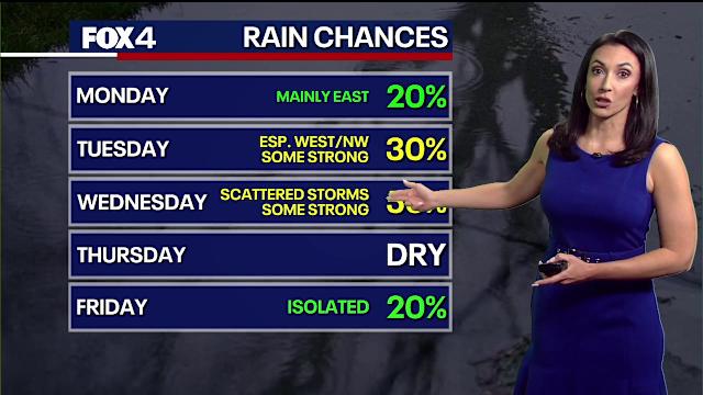
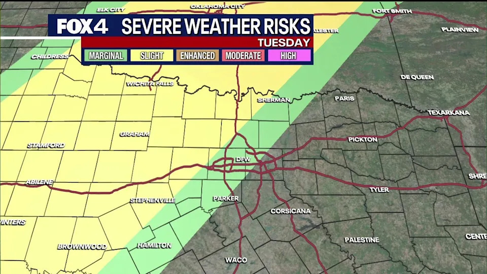
The Brief

North Texas faces an active weather week as scattered thunderstorms move through Tuesday and Wednesday, bringing threats of large hail, damaging winds and isolated tornadoes.

While Monday and Thursday offer brief breaks with warm temperatures in the 90s, a cold front arriving Saturday morning will trigger a final line of storms.

Conditions are expected to clear by Saturday afternoon, leading to a drier and cooler conclusion to the weekend.

DALLAS - Prepare for an active week as scattered thunderstorms move through North Texas early this week, with a second round of rain likely arriving for the weekend.

Monday will remain mostly quiet with low rain chances, primarily east of the Metroplex. The day will be muggy and humid with the potential for a few isolated storms. Expect warm temperatures, with highs reaching the low 90s in some areas.

Scattered thunderstorms are expected to sweep through the region Tuesday and Wednesday nights. These storms carry risks of large hail, damaging winds and isolated tornadoes.

Storm chances increase Tuesday as a system develops near the dryline to the west. A few of these storms will track toward the area late Tuesday afternoon and evening. By Wednesday, a stronger disturbance brings the highest chance of rain for the workweek, with some storms expected to be strong to severe.

The region will see a brief break to end the workweek on Thursday. While isolated showers remain possible Friday, temperatures will stay warm. A cold front arrives early Saturday morning, bringing a line of storms. Conditions will dry out and cool down for the remainder of the weekend.

The Source

Information in this article comes from the National Weather Service and FOX 4 Forecasters.