yahoo Press
What to expect as Virginia faces severe storm, possible tornadoes, cold
Images

1 / 10
2 / 10

3 / 10

4 / 10

5 / 10
6 / 10
7 / 10

8 / 10

9 / 10

10 / 10
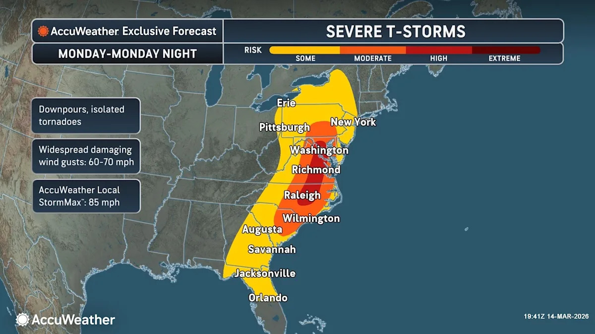
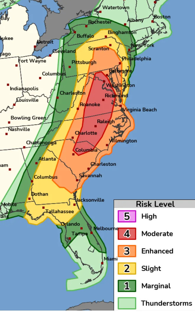
Spring is making one heck of an entrance.

After a week of record high temperatures, a major winter storm affecting the Plains and Midwest with impacts felt far from the storm's center is forecast to arrive overnight Sunday, March 15 and especially on Monday for parts of the Mid-Atlantic states and southeast.

Widespread severe thunderstorms bringing flooding downpours are forecast Monday, according to the NOAA Storm Prediction Center. Tornadoes, potentially strong, and particularly damaging winds are most likely from South Carolina into Maryland during the afternoon, the NOAA said Sunday.

"While damaging straight-line winds are the most likely severe weather hazard, a few tornadoes, including the possibility of an especially intense tornado, cannot be ruled out, especially from near the Baltimore and Washington, D.C., metro areas through Virginia and into North Carolina,” said Jonathan Porter, AccuWeather chief meteorologist.

For the eastern and central parts of Virginia including Washington, DC and Richmond, the NOAA upgraded the area to a moderate risk level four with a 15% chance of tornadoes, some possibly strong, as the storm spreads eastward from the Appalachians to the East Coast during Monday afternoon.

The Sunday forecast during the day in the Augusta County region calls for a high of 56 degrees, calm and sunny weather during the day with a slight chance of rain in the afternoon. The warm front will lift toward the area bringing warmer and more humid air, increasing clouds and rain showers overnight, according to the National Weather Service.

A strong cold front will cross the region Monday afternoon and evening. This system will likely bring gusty winds and severe thunderstorms, which may even include a few tornadoes, the NWS Baltimore/Washington DC weather forecast office said Sunday. NOAA Storm Prediction Center map of Augusta County shows a 10% slight risk of tornadoes.

Temperature in Augusta County will rise to near 65 by noon Monday, then fall to around 52 during the remainder of the day. Chance of precipitation is 100%. New rainfall amounts between a quarter and half of an inch are possible.

Cold and blustery conditions will follow the front Monday night into Tuesday, with a chance of rain and snow showers before 11 p.m., then a chance of rain showers between 11 p.m. and 2 a.m. with a low around 24 degrees. Snow showers are expected in the Blue Ridge and Allegheny mountains.

Tuesday's forecast calls for mostly sunny weather, with a high near 36. West winds are expected to be 11 to 17 mph, with gusts as high as 31 mph. Overnight temperatures will then plummet to a low around 19 degrees Tuesday and a low around 27 degrees Wednesday.

By Thursday, seasonal temperatures will return with a high near 56 as we greet spring on Friday.

More: With Assembly passage, Virginia inches closer to cannabis retail sales

More: Duke basketball holds on to take down Virginia, claims ACC championship: Score, highlights

Monique Calello is a reporter at The News Leader/USA Today Network. Connect with her at mcalello@newsleader.com.

This article originally appeared on Staunton News Leader: Virginia weather forecast includes severe storm, tornadoes, cold front