yahoo Press
Archaeologists Were Scanning Farmland—And Found 5,000-Year-Old Burial Mounds
Images
1 / 10

2 / 10

3 / 10

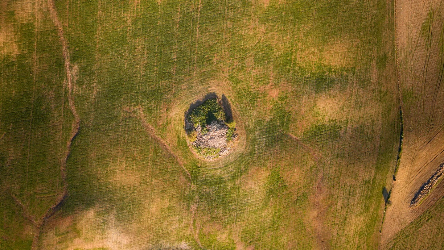
4 / 10

5 / 10

6 / 10

7 / 10

8 / 10

9 / 10

10 / 10
Here’s what you’ll learn when you read this story:

Using a suite of technological tools, researchers are locating Neolithic burial mounds and settlements hidden beneath the landscape of the Czech Republic.

Often the burial sites aren’t visible to the human eye, but remote sensing technologies highlight the subtle landscape differences.

These 5,000-year-old burial mounds sat just outside ancient settlement areas.

Lurking just below Bohemian farm fields in the Czech Republic sit thousands of archaeological sites, including dozens of Neolithic burial mounds, many 5,000 years old. They can’t be seen just by looking, but a suite of technologies is now revealing some of Europe’s oldest monumental architecture for the very first time.

The experts were already aware that the long barrows—elongated burial mounds common around 3000 B.C.E.—were present throughout Bohemia, but they simply couldn’t see them. Fortunately, a new study published in Archaeological Prospection has demonstrated how remote sensing strategies can bring these once-hidden prehistorical burial monuments into view, even revealing the settlement areas around the sites.

By combining aerial survey, magnetometry, and airborne laser scanning, “it has been possible not only to detect burial monuments that are no longer recognizable in the present-day terrain but also to reconstruct key aspects of their original form, preservation state, and landscape setting,” the authors wrote.

The team of Czech researchers, led by the Institute of Archaeology at the University of Wroclaw in collaboration with the universities of Pilsen, Hradec Kralove, and Prague, captured patterns in crop growth, pinpointed elevation changes down to centimeters, and used ground-based magnetic surveys to map variations in soil magnetism. The combination revealed a completely fresh Neolithic view of the terrain, even in intensively cultivated landscapes.

“Aerial imagery, especially oblique photographs, remains indispensable for recognizing the characteristic ground plans of long barrows,” the authors wrote, “while magnetic survey provides critical insights into their internal structure, constructional elements, and associated features, including burial pits that are otherwise obscured by extensive positive cropmarks.”

The team found roughly 2,900 archaeological features in the study area within four major clusters. Included were the obvious signature signs of Neolithic long barrows, some of the earliest monumental tombs ever built in Central Europe. Along with the burial mounds, experts said they located additional circular monuments and burial-related structures at the sites, which can all help to show funerary practices of the day.

The monuments and structures in the study served as “ritual anchors within the landscape,” with evidence showing how prehistoric communities regularly returned to the locations and reused them over many centuries. “In this sense,” the authors wrote, “Neolithic long barrows formed the nuclei of enduring ritual.”

The discoveries gave the team a new understanding of the typical framework of a settlement zone and how the burial mounds integrated with it, showing strong evidence that long barrows were “deliberately constructed at the margins of the settlement.” The team regularly found that the burial sites were pushed to the outskirts, as much as 1,500 feet from the communities, creating a deliberate buffer between the living and the buried. This spatial separation had long been theorized to exist, but now technology has confirmed it for the first time.

“The results underline the value of multi-method remote sensing not only as a tool for site detection but also as a means of reconstructing prehistoric land-use strategies and social practices,” the team wrote. “In the case of Bohemian long barrows, remote sensing reveals a landscape structured by a persistent conceptual division between the realms of the living and the dead—a division that was maintained and renegotiated over millennia.”

Even in regions where intensive agriculture has long been assumed to have erased prehistoric monumental architecture, significant traces of Neolithic burial monuments and their associated landscapes still survived. “Their detection and interpretation depend not on a single optimal method,” they wrote, “but on the systematic integration of complementary remote sensing techniques.”

You Might Also Like

The Do’s and Don’ts of Using Painter’s Tape

The Best Portable BBQ Grills for Cooking Anywhere

Can a Smart Watch Prolong Your Life?